
Laufenberg topographic map
Interactive map
Click on the map to display elevation.
About this map
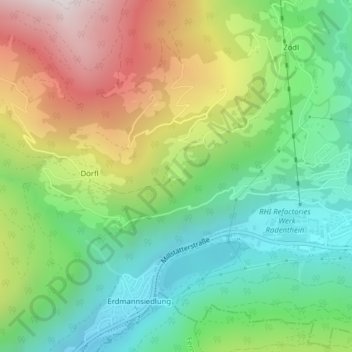
Name: Laufenberg topographic map, elevation, terrain.
Average elevation: 1,039 m
Minimum elevation: 627 m
Maximum elevation: 1,698 m
Other topographic maps
Click on a map to view its topography, its elevation and its terrain.
Obertweng
Österreich > Kärnten > Bezirk Spittal an der Drau > Radenthein
Obertweng, Radenthein, Bezirk Spittal an der Drau, Kärnten, 9545, Österreich
Average elevation: 1,073 m
Döbriach
Österreich > Kärnten > Bezirk Spittal an der Drau > Radenthein > Döbriach
Döbriach, Radenthein, Bezirk Spittal an der Drau, Kärnten, 9545, Österreich
Average elevation: 920 m