
Navan topographic map
Interactive map
Click on the map to display elevation.
About this map
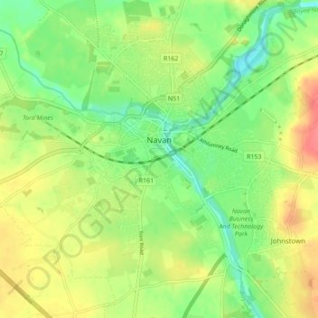
Name: Navan topographic map, elevation, terrain.
Average elevation: 52 m
Minimum elevation: 26 m
Maximum elevation: 84 m
Other topographic maps
Click on a map to view its topography, its elevation and its terrain.
Slane ED
Slane ED, The Municipal District of Laytown — Bettystown, Comté de Meath, Leinster, Irlande
Average elevation: 79 m
Hill of Tara
Hill of Tara, The Municipal District of Ashbourne, Comté de Meath, Leinster, C15 NYY6, Irlande
Average elevation: 106 m
The Municipal District of Navan
The Municipal District of Navan, Comté de Meath, Leinster, Irlande
Average elevation: 62 m
The Municipal District of Ratoath
The Municipal District of Ratoath, Comté de Meath, Leinster, Irlande
Average elevation: 87 m
Donore
Donore, Saint Mary's ED, The Municipal District of Laytown — Bettystown, Comté de Meath, Leinster, Irlande
Average elevation: 58 m
Boyne
Boyne, Kilcooly ED, The Municipal District of Trim, Comté de Meath, Leinster, C15 X3Y2, Irlande
Average elevation: 57 m
Bettystown
Bettystown, The Municipal District of Laytown — Bettystown, Comté de Meath, Leinster, A92 AH27, Irlande
Average elevation: 6 m