
Province of Tumbes topographic map
Interactive map
Click on the map to display elevation.
About this map
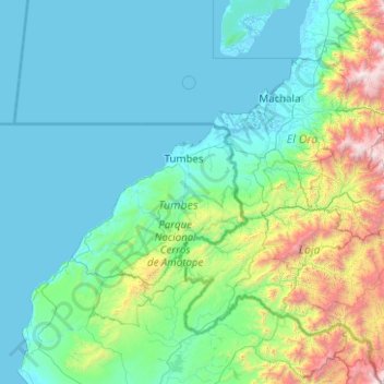
Name: Province of Tumbes topographic map, elevation, terrain.
Location: Province of Tumbes, Tumbes, Peru (-4.75000 -81.41667 -2.75000 -79.41667)
Average elevation: 460 m
Minimum elevation: -2 m
Maximum elevation: 4,014 m
Other topographic maps
Click on a map to view its topography, its elevation and its terrain.
Río Tumbes
Peru > Tumbes > Pampas de Hospital
Río Tumbes, Pampas de Hospital, Province of Tumbes, Tumbes, Peru
Average elevation: 524 m
District of Tumbes
District of Tumbes, Province of Tumbes, Tumbes, 072, Peru
Average elevation: 24 m