
Make a donation
Gear up for your next adventure:
As an Amazon Associate, this site earns from qualifying purchases at no extra cost to you.
Beirut Governorate topographic map
Click on the map to display elevation.
Make a donation
Gear up for your next adventure:
As an Amazon Associate, this site earns from qualifying purchases at no extra cost to you.
About this map
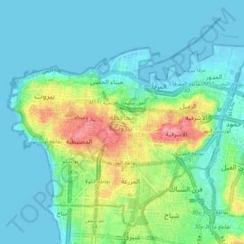
Name: Beirut Governorate topographic map, elevation, terrain.
Location: Beirut Governorate, Lebanon (33.86233 35.46681 33.91611 35.54258)
Average elevation: 27 m
Minimum elevation: -4 m
Maximum elevation: 115 m
Make a donation
Gear up for your next adventure:
As an Amazon Associate, this site earns from qualifying purchases at no extra cost to you.
Other topographic maps
Click on a map to view its topography, its elevation and its terrain.
Faraya
Lebanon > Keserwan-Jbeil Governorate
Faraya (Arabic: فاريا) is a village and municipality in the Keserwan District of the Keserwan-Jbeil Governorate, Lebanon. It is located 46 kilometers north of Beirut. Elevation start from 1290 meters to 2000 meters above sea level and its total land area is 870 hectares. Faraya's inhabitants are…
Average elevation: 1,589 m