
Make a donation
Gear up for your next adventure:
As an Amazon Associate, this site earns from qualifying purchases at no extra cost to you.
Tiefenbachklamm topographic map
Click on the map to display elevation.
Make a donation
Gear up for your next adventure:
As an Amazon Associate, this site earns from qualifying purchases at no extra cost to you.
About this map
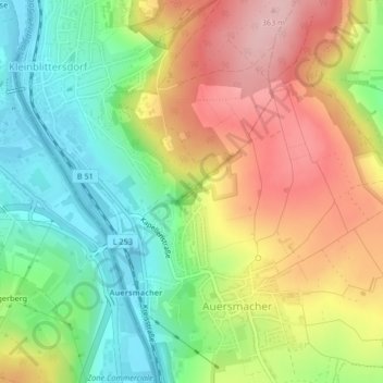
Name: Tiefenbachklamm topographic map, elevation, terrain.
Average elevation: 270 m
Minimum elevation: 190 m
Maximum elevation: 364 m
Make a donation
Gear up for your next adventure:
As an Amazon Associate, this site earns from qualifying purchases at no extra cost to you.
Other topographic maps
Click on a map to view its topography, its elevation and its terrain.
Bliesransbach
Deutschland > Saarland > Regionalverband Saarbrücken > Kleinblittersdorf
Im Bannbezirk bewirken die Höhenunterschiede vom Blieslauf (195 m über NN) über die mittlere Ostlage (235 m über NN) bis hin zu dem umlaufenden Bergrücken (360 m über NN) verschiedene Kleinklimazonen, die auch als Vegetationszonen erkennbar sind. In den kühlen, feuchten Niederungen der von Pappeln und…
Average elevation: 286 m