
Make a donation
Gear up for your next adventure:
As an Amazon Associate, this site earns from qualifying purchases at no extra cost to you.
Sagar topographic map
Click on the map to display elevation.
Make a donation
Gear up for your next adventure:
As an Amazon Associate, this site earns from qualifying purchases at no extra cost to you.
Sagar
Sagar CD block is located at 21°39′10″N 88°04′31″E / 21.6528°N 88.0753°E / 21.6528; 88.0753. It has an average elevation of 4 metres (13 ft).
Make a donation
Gear up for your next adventure:
As an Amazon Associate, this site earns from qualifying purchases at no extra cost to you.
About this map
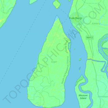
Name: Sagar topographic map, elevation, terrain.
Location: Sagar, South 24 Parganas District, West Bengal, India (21.62877 88.04167 21.92501 88.18400)
Average elevation: 2 m
Minimum elevation: -3 m
Maximum elevation: 11 m
Make a donation
Gear up for your next adventure:
As an Amazon Associate, this site earns from qualifying purchases at no extra cost to you.
Other topographic maps
Click on a map to view its topography, its elevation and its terrain.
Farakka
India > West Bengal > Farakka
Jangipur subdivision is crowded with 52 census towns and as such it had to be presented in two location maps. One of the maps can be seen alongside. The subdivision is located in the Rarh region that is spread over from adjoining Santhal Pargana division of Jharkhand. The land is slightly higher in altitude…
Average elevation: 24 m