
Navajo Lake State Park topographic map
Interactive map
Click on the map to display elevation.
About this map
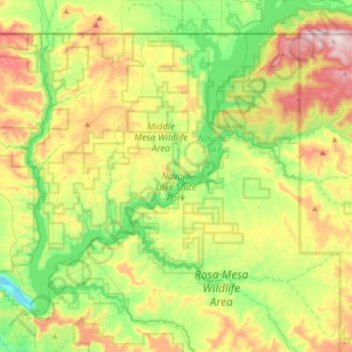
Name: Navajo Lake State Park topographic map, elevation, terrain.
Average elevation: 1,966 m
Minimum elevation: 1,738 m
Maximum elevation: 2,338 m
Other topographic maps
Click on a map to view its topography, its elevation and its terrain.
Navajo Dam
United States > New Mexico > San Juan County > Navajo Dam
Navajo Dam, San Juan County, New Mexico, United States
Average elevation: 1,813 m