
Δήμος Παλαμά topographic map
Interactive map
Click on the map to display elevation.
About this map
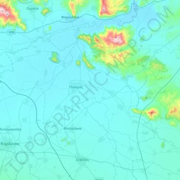
Name: Δήμος Παλαμά topographic map, elevation, terrain.
Average elevation: 130 m
Minimum elevation: 81 m
Maximum elevation: 708 m
Other topographic maps
Click on a map to view its topography, its elevation and its terrain.
Karditsa
Grèce > Thessalie-Grèce centrale > Περιφερειακή Ενότητα Καρδίτσας
Karditsa, Δήμος Καρδίτσας, Περιφερειακή Ενότητα Καρδίτσας, Thessalie, Thessalie-Grèce centrale, 431 00, Grèce
Average elevation: 223 m