
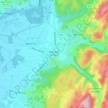
Saint-Jean-le-Vieux topographic map
Interactive map
Click on the map to display elevation.
About this map
Name: Saint-Jean-le-Vieux topographic map, elevation, terrain.
Average elevation: 324 m
Minimum elevation: 237 m
Maximum elevation: 598 m
Other topographic maps
Click on a map to view its topography, its elevation and its terrain.
Le Roy
France > Auvergne-Rhône-Alpes > Ain > Saint-Jean-le-Vieux
Le Roy, Saint-Jean-le-Vieux, Nantua, Ain, Auvergne-Rhône-Alpes, France métropolitaine, 01640, France
Average elevation: 349 m
Cheminand
France > Auvergne-Rhône-Alpes > Ain > Saint-Jean-le-Vieux
Cheminand, Saint-Jean-le-Vieux, Nantua, Ain, Auvergne-Rhône-Alpes, France métropolitaine, 01640, France
Average elevation: 343 m
Le Battoir
France > Auvergne-Rhône-Alpes > Ain > Saint-Jean-le-Vieux
Le Battoir, Saint-Jean-le-Vieux, Nantua, Ain, Auvergne-Rhône-Alpes, France métropolitaine, 01640, France
Average elevation: 349 m