Geolocate

Austin topographic map

Click on the map to display elevation.

About this map

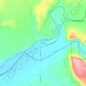
Name: Austin topographic map, elevation, terrain.

Location: Austin, Delta County, Colorado, 81410, United States (38.76109 -107.97090 38.80109 -107.93090)

Average elevation: 1,576 m

Minimum elevation: 1,523 m

Maximum elevation: 1,718 m

Other topographic maps

Click on a map to view its topography, its elevation and its terrain.

Hotchkiss

United States > Colorado > Delta County

Average elevation: 1,655 m

Crawford State Park

United States > Colorado > Delta County

Average elevation: 2,033 m

Cedaredge

United States > Colorado > Delta County

Located in a protected valley at 6,100 feet (1,900 m) in elevation, the Cedaredge Golf Club course has natural cedars and winding creek beds.

Average elevation: 1,883 m

Rim Rock Lake

United States > Colorado > Delta County

Average elevation: 3,113 m

Gear up for your next adventure:

💧Reusable Water Bottle - Durable water bottles for hydration on trails
🧣Merino Neck Gaiter - Protects against wind, sun, and cold at high altitudes
🧤Rechargeable Heated Gloves - Extreme warmth for Canadian winter expeditions
🥾Hiking Leggings - Comfortable leggings for outdoor activities
🩹Moleskin Blister Pads - Direct protection for painful foot pressure points

As an Amazon Associate, this site earns from qualifying purchases at no extra cost to you.