Geolocate

Crete topographic map

Click on the map to display elevation.

About this map

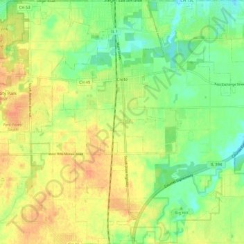
Name: Crete topographic map, elevation, terrain.

Location: Crete, Will County, Illinois, United States (41.39152 -87.67068 41.46999 -87.56946)

Average elevation: 224 m

Minimum elevation: 205 m

Maximum elevation: 241 m

Other topographic maps

Click on a map to view its topography, its elevation and its terrain.

Drummond

United States > Illinois > Will County

Average elevation: 167 m

Puddle Pond

United States > Illinois > Will County > Plainfield

Average elevation: 187 m

Arbury Hills

United States > Illinois > Will County

Average elevation: 216 m

Gear up for your next adventure:

🦌Outdoor Trail Camera - Monitor wildlife activity near your favorite spots
🕶️Polarized Sunglasses - Reduces glare from snow and water at high elevations
🧴Bear Spray Holster - Quick-access carry for essential Canadian wilderness safety
🔥Camping Stove - Portable stoves to cook outdoors with ease
🧥Waterproof Hiking Jacket - Protect yourself from rain and wind while hiking

As an Amazon Associate, this site earns from qualifying purchases at no extra cost to you.