
Make a donation
Gear up for your next adventure:
As an Amazon Associate, this site earns from qualifying purchases at no extra cost to you.
Etna topographic map
Click on the map to display elevation.
Make a donation
Gear up for your next adventure:
As an Amazon Associate, this site earns from qualifying purchases at no extra cost to you.
Etna
Etna has a beautiful hilly topography with dramatic exposed shale rock as you enter Etna borough off of Route 28 from Pittsburgh. The downtown area is a quaint main street named one of the best main streets in Pennsylvania in 2021.
Make a donation
Gear up for your next adventure:
As an Amazon Associate, this site earns from qualifying purchases at no extra cost to you.
About this map
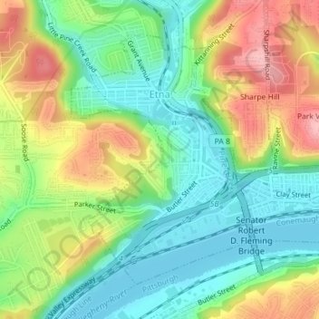
Name: Etna topographic map, elevation, terrain.
Location: Etna, Allegheny County, Pennsylvania, United States (40.48750 -79.95828 40.50861 -79.93819)
Average elevation: 274 m
Minimum elevation: 218 m
Maximum elevation: 360 m
Make a donation
Gear up for your next adventure:
As an Amazon Associate, this site earns from qualifying purchases at no extra cost to you.