
Thank you for supporting this site ❤️
Make a donation
Make a donation
Gear up for your next adventure:
As an Amazon Associate, this site earns from qualifying purchases at no extra cost to you.
Gavelli topographic map
Click on the map to display elevation.
Thank you for supporting this site ❤️
Make a donation
Make a donation
Gear up for your next adventure:
As an Amazon Associate, this site earns from qualifying purchases at no extra cost to you.
About this map
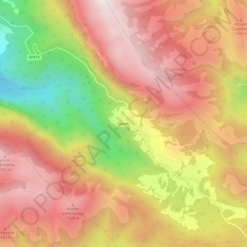
Name: Gavelli topographic map, elevation, terrain.
Location: Gavelli, Sant'Anatolia di Narco, Perugia, Umbria, 06040, Italy (42.67174 12.87485 42.71174 12.91485)
Average elevation: 1,232 m
Minimum elevation: 628 m
Maximum elevation: 1,646 m
Thank you for supporting this site ❤️
Make a donation
Make a donation
Gear up for your next adventure:
As an Amazon Associate, this site earns from qualifying purchases at no extra cost to you.