
Make a donation
Gear up for your next adventure:
As an Amazon Associate, this site earns from qualifying purchases at no extra cost to you.
Poggio Cancelli topographic map
Click on the map to display elevation.
Make a donation
Gear up for your next adventure:
As an Amazon Associate, this site earns from qualifying purchases at no extra cost to you.
About this map
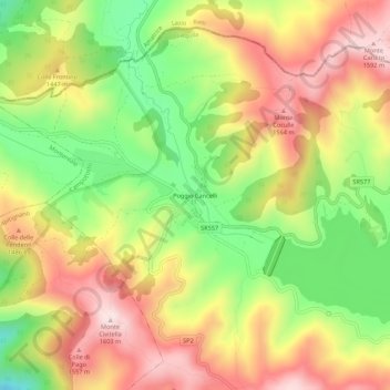
Name: Poggio Cancelli topographic map, elevation, terrain.
Location: Poggio Cancelli, Campotosto, L'Aquila, Abruzzo, 67014, Italia (42.54250 13.30680 42.58250 13.34680)
Average elevation: 1,394 m
Minimum elevation: 1,178 m
Maximum elevation: 1,598 m
Make a donation
Gear up for your next adventure:
As an Amazon Associate, this site earns from qualifying purchases at no extra cost to you.
Other topographic maps
Click on a map to view its topography, its elevation and its terrain.
Lago di Campotosto
Italia > Abruzzo > L'Aquila > Campotosto
Posto ad un'altitudine di 1.313 m s.l.m., con una superficie di 1400 ettari ed una profondità massima compresa tra i 30 e i 35 metri, dal punto di vista idrografico fa parte del bacino idrografico del fiume Vomano, che scende nell'omonima valle fino al mar Adriatico e della riserva naturale statale omonima,…
Average elevation: 1,374 m