Geolocate

sn3 topographic map

Click on the map to display elevation.

About this map

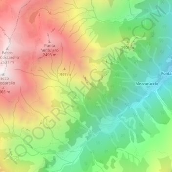
Name: sn3 topographic map, elevation, terrain.

Location: sn3, Rassa, Vercelli, Piedmont, Italy (45.75272 7.95618 45.77272 7.97618)

Average elevation: 1,833 m

Minimum elevation: 1,185 m

Maximum elevation: 2,640 m

Gear up for your next adventure:

🥾Light Trekking Boots - Supportive boots for multi-day treks
🧴Waterproofing Spray - Restore the DWR coating on jackets and tents
🪑Ultralight Camping Stool - Compact seating for rest stops during long hikes
💡Portable Camping Lamp - Rechargeable lamp for campsite lighting
🧢Sun Protection Cap - Breathable cap to protect from sun exposure

As an Amazon Associate, this site earns from qualifying purchases at no extra cost to you.