
Lourmarin topographic map
Interactive map
Click on the map to display elevation.
About this map
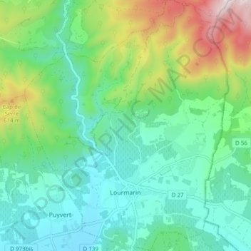
Name: Lourmarin topographic map, elevation, terrain.
Average elevation: 357 m
Minimum elevation: 168 m
Maximum elevation: 840 m
Other topographic maps
Click on a map to view its topography, its elevation and its terrain.
Lacoste
Francia > Provenza-Alpes-Costa Azul > Vaucluse
Lacoste, Apt, Vaucluse, Provenza-Alpes-Costa Azul, Francia metropolitana, 84480, Francia
Average elevation: 363 m