
Make a donation
Gear up for your next adventure:
As an Amazon Associate, this site earns from qualifying purchases at no extra cost to you.
Pocatello topographic map
Click on the map to display elevation.
Make a donation
Gear up for your next adventure:
As an Amazon Associate, this site earns from qualifying purchases at no extra cost to you.
Pocatello
The city is at an elevation of 4,462 feet (1,360 m) above sea level and it sits on the Portneuf River in the Snake River Plain ecoregion. Pocatello covers a land area of 33.36 square miles (86.4 square kilometers).
Make a donation
Gear up for your next adventure:
As an Amazon Associate, this site earns from qualifying purchases at no extra cost to you.
About this map
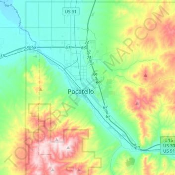
Name: Pocatello topographic map, elevation, terrain.
Location: Pocatello, Bannock County, Idaho, United States (42.80215 -112.63186 42.93149 -112.36026)
Average elevation: 1,580 m
Minimum elevation: 1,328 m
Maximum elevation: 2,209 m
Make a donation
Gear up for your next adventure:
As an Amazon Associate, this site earns from qualifying purchases at no extra cost to you.