
Thank you for supporting this site ❤️
Make a donation
Make a donation
Gear up for your next adventure:
As an Amazon Associate, this site earns from qualifying purchases at no extra cost to you.
Epçeler topographic map
Click on the map to display elevation.
Thank you for supporting this site ❤️
Make a donation
Make a donation
Gear up for your next adventure:
As an Amazon Associate, this site earns from qualifying purchases at no extra cost to you.
About this map
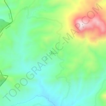
Name: Epçeler topographic map, elevation, terrain.
Location: Epçeler, Nallıhan, Ankara, Central Anatolia Region, Turkey (40.21870 31.07634 40.25870 31.11634)
Average elevation: 1,075 m
Minimum elevation: 859 m
Maximum elevation: 1,536 m
Thank you for supporting this site ❤️
Make a donation
Make a donation
Gear up for your next adventure:
As an Amazon Associate, this site earns from qualifying purchases at no extra cost to you.