
Thank you for supporting this site ❤️
Make a donation
Make a donation
Gear up for your next adventure:
As an Amazon Associate, this site earns from qualifying purchases at no extra cost to you.
Petrelle topographic map
Click on the map to display elevation.
Thank you for supporting this site ❤️
Make a donation
Make a donation
Gear up for your next adventure:
As an Amazon Associate, this site earns from qualifying purchases at no extra cost to you.
About this map
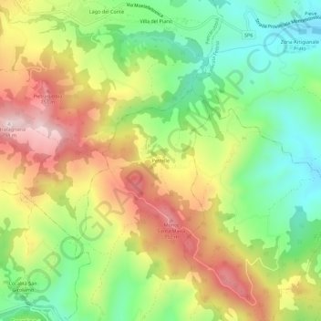
Name: Petrelle topographic map, elevation, terrain.
Location: Petrelle, Piandimeleto, Pesaro e Urbino, 61023, Italia (43.76465 12.38049 43.80465 12.42049)
Average elevation: 527 m
Minimum elevation: 320 m
Maximum elevation: 784 m
Thank you for supporting this site ❤️
Make a donation
Make a donation
Gear up for your next adventure:
As an Amazon Associate, this site earns from qualifying purchases at no extra cost to you.