
Make a donation
Gear up for your next adventure:
As an Amazon Associate, this site earns from qualifying purchases at no extra cost to you.
Naro topographic map
Click on the map to display elevation.
Make a donation
Gear up for your next adventure:
As an Amazon Associate, this site earns from qualifying purchases at no extra cost to you.
Naro
Naro liegt 30 Kilometer östlich von Agrigent auf einer Höhe von 520 Metern. Der Ort hat 7346 Einwohner (Stand 31. Dezember 2019), diese wohnen auf einer Fläche von 207 Quadratkilometern. Der Haupterwerb der Einwohner sind die Landwirtschaft und die Textilindustrie.
Make a donation
Gear up for your next adventure:
As an Amazon Associate, this site earns from qualifying purchases at no extra cost to you.
About this map
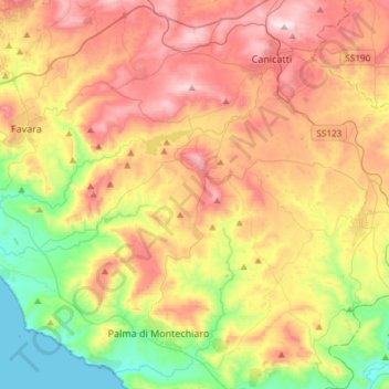
Name: Naro topographic map, elevation, terrain.
Location: Naro, Agrigent, Sizilien, 92028, Italien (37.20408 13.69660 37.34771 13.99429)
Average elevation: 299 m
Minimum elevation: 0 m
Maximum elevation: 642 m
Make a donation
Gear up for your next adventure:
As an Amazon Associate, this site earns from qualifying purchases at no extra cost to you.
Other topographic maps
Click on a map to view its topography, its elevation and its terrain.
Capreria
Italien > Sizilien > Agrigent > Palma di Montechiaro > Marina di Palma
Average elevation: 70 m