
Thank you for supporting this site ❤️
Make a donation
Make a donation
Gear up for your next adventure:
As an Amazon Associate, this site earns from qualifying purchases at no extra cost to you.
Doncei topographic map
Click on the map to display elevation.
Thank you for supporting this site ❤️
Make a donation
Make a donation
Gear up for your next adventure:
As an Amazon Associate, this site earns from qualifying purchases at no extra cost to you.
About this map
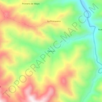
Name: Doncei topographic map, elevation, terrain.
Location: Doncei, Soritor, Moyobamba, San Martín, Perú (-6.27534 -77.07306 -6.23534 -77.03306)
Average elevation: 1,331 m
Minimum elevation: 1,034 m
Maximum elevation: 1,672 m
Thank you for supporting this site ❤️
Make a donation
Make a donation
Gear up for your next adventure:
As an Amazon Associate, this site earns from qualifying purchases at no extra cost to you.