
Make a donation
Gear up for your next adventure:
As an Amazon Associate, this site earns from qualifying purchases at no extra cost to you.
Udenhain topographic map
Click on the map to display elevation.
Make a donation
Gear up for your next adventure:
As an Amazon Associate, this site earns from qualifying purchases at no extra cost to you.
Udenhain
Udenhain, ein Haufendorf im südlichen Vogelsberg, liegt im Gegensatz zu den anderen Ortsteilen Schlierbachs, östlich der Bracht. Die Höhenlage schwankt zwischen 160 m und 345 m NHN. Von nordöstlicher in südwestlicher Richtung durchfließt den Ort der Krötenbach, der teilweise verrohrt ist.
Make a donation
Gear up for your next adventure:
As an Amazon Associate, this site earns from qualifying purchases at no extra cost to you.
About this map
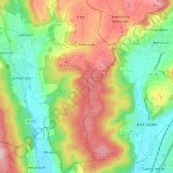
Name: Udenhain topographic map, elevation, terrain.
Location: Udenhain, Brachttal, Main-Kinzig-Kreis, Hessen, Deutschland (50.27227 9.30514 50.33150 9.34864)
Average elevation: 244 m
Minimum elevation: 140 m
Maximum elevation: 379 m
Make a donation
Gear up for your next adventure:
As an Amazon Associate, this site earns from qualifying purchases at no extra cost to you.