
Make a donation
Gear up for your next adventure:
As an Amazon Associate, this site earns from qualifying purchases at no extra cost to you.
Gangavalli topographic map
Click on the map to display elevation.
Make a donation
Gear up for your next adventure:
As an Amazon Associate, this site earns from qualifying purchases at no extra cost to you.
Gangavalli
Gangavalli is located at 11°29′N 78°39′E / 11.48°N 78.65°E / 11.48; 78.65. It has an average elevation of 292 metres (958 feet).
Make a donation
Gear up for your next adventure:
As an Amazon Associate, this site earns from qualifying purchases at no extra cost to you.
About this map
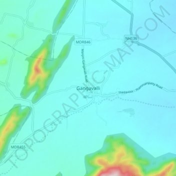
Name: Gangavalli topographic map, elevation, terrain.
Location: Gangavalli, Salem District, Tamil Nadu, 636105, India (11.45968 78.60471 11.53968 78.68471)
Average elevation: 234 m
Minimum elevation: 183 m
Maximum elevation: 631 m
Make a donation
Gear up for your next adventure:
As an Amazon Associate, this site earns from qualifying purchases at no extra cost to you.