Geolocate

Morganton topographic map

Click on the map to display elevation.

About this map
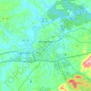
Name: Morganton topographic map, elevation, terrain.

Location: Morganton, Burke County, North Carolina, 28655, United States (35.69588 -81.80031 35.78386 -81.64554)

Average elevation: 355 m

Minimum elevation: 299 m

Maximum elevation: 633 m

Other topographic maps

Click on a map to view its topography, its elevation and its terrain.

Jonas Ridge

United States > North Carolina > Burke County

Average elevation: 1,136 m

Petche Gap

United States > North Carolina > Burke County

Average elevation: 441 m

Parkhill

United States > North Carolina > Burke County

Average elevation: 368 m

Jonas Ridge

United States > North Carolina > Burke County

Average elevation: 1,136 m

Linville

United States > North Carolina > Burke County

Average elevation: 412 m

Gold

United States > North Carolina > Burke County

Average elevation: 369 m

Jonas Ridge

United States > North Carolina > Burke County

Average elevation: 1,136 m

Gear up for your next adventure:

🧥Waterproof Jacket - Lightweight rain jackets for hiking and outdoor activities
🧭Orienteering Kit - Tools for map reading and navigation in the wild
🧦Hiking Socks - Moisture-wicking and comfortable socks for long hikes
🔦UV Flashlight - Detect minerals or specific insects in the dark
🧼Biodegradable Camp Soap - Environmentally friendly cleaning for gear and body

As an Amazon Associate, this site earns from qualifying purchases at no extra cost to you.