Geolocate

Septeuil topographic map

Click on the map to display elevation.

About this map
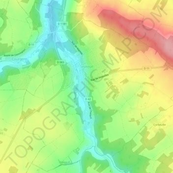
Name: Septeuil topographic map, elevation, terrain.

Location: Septeuil, Mantes-la-Jolie, Yvelines, Ile-de-France, Metropolitan France, 78790, France (48.86999 1.66089 48.90644 1.71735)

Average elevation: 111 m

Minimum elevation: 53 m

Maximum elevation: 179 m

Other topographic maps

Click on a map to view its topography, its elevation and its terrain.

Rodon

France > Ile-de-France > Yvelines

Average elevation: 167 m

Hautvilliers

France > Ile-de-France > Yvelines > Chevreuse

Average elevation: 127 m

La Corse

France > Ile-de-France > Yvelines > Élancourt

Average elevation: 165 m

Gear up for your next adventure:

🧦Hiking Liner Socks - Thin base layer to prevent friction and blisters
🧼Travel Hand Sanitizer - Keep hands clean when water is scarce
🔦LED Headtorch - Bright and durable light for night activities
🛌Insulated Sleeping Pad - Critical thermal barrier between you and the cold ground
🏃Hydration Running Vest - Carry water and maps close to your body for speed

As an Amazon Associate, this site earns from qualifying purchases at no extra cost to you.