
Make a donation
Gear up for your next adventure:
As an Amazon Associate, this site earns from qualifying purchases at no extra cost to you.
Tomatitas topographic map
Click on the map to display elevation.
Make a donation
Gear up for your next adventure:
As an Amazon Associate, this site earns from qualifying purchases at no extra cost to you.
About this map
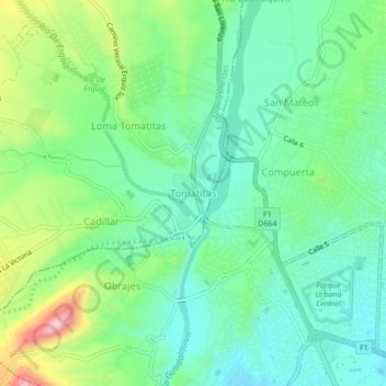
Name: Tomatitas topographic map, elevation, terrain.
Average elevation: 1,956 m
Minimum elevation: 1,889 m
Maximum elevation: 2,113 m
Make a donation
Gear up for your next adventure:
As an Amazon Associate, this site earns from qualifying purchases at no extra cost to you.
Other topographic maps
Click on a map to view its topography, its elevation and its terrain.
Pantipampa
Bolivia > Tarija > Eustaquio Méndez > Municipio Villa San Lorenzo
Average elevation: 2,766 m
San Lorenzo
Bolivia > Tarija > Eustaquio Méndez > Municipio Villa San Lorenzo
San Lorenzo es la capital de la provincia de Méndez y está situado en la mitad oriental de ésta, al noroeste del departamento de Tarija. La localidad se encuentra a 2001 m s. n. m., se encuentra en el margen izquierdo del río Calama y al margen derecho el río Nuevo Guadalquivir, esta a 15 km al norte de…
Average elevation: 2,004 m