
Make a donation
Gear up for your next adventure:
As an Amazon Associate, this site earns from qualifying purchases at no extra cost to you.
Labuerda/A Buerda topographic map
Click on the map to display elevation.
Make a donation
Gear up for your next adventure:
As an Amazon Associate, this site earns from qualifying purchases at no extra cost to you.
About this map
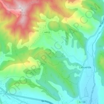
Name: Labuerda/A Buerda topographic map, elevation, terrain.
Location: Labuerda/A Buerda, Sobrarbe, Huesca, Aragón, Spanje (42.43088 0.08501 42.48504 0.14175)
Average elevation: 759 m
Minimum elevation: 538 m
Maximum elevation: 1,287 m
Make a donation
Gear up for your next adventure:
As an Amazon Associate, this site earns from qualifying purchases at no extra cost to you.
Other topographic maps
Click on a map to view its topography, its elevation and its terrain.
Banastón
Spanje > Aragón > Sobrarbe > Aínsa-Sobrarbe/L´Aínsa-Sobrarbe > Las Cambras
Average elevation: 613 m
Santa Maria de Buil
Spanje > Aragón > Sobrarbe > Aínsa-Sobrarbe/L´Aínsa-Sobrarbe
Average elevation: 788 m
Make a donation
Gear up for your next adventure:
As an Amazon Associate, this site earns from qualifying purchases at no extra cost to you.