
Thank you for supporting this site ❤️
Make a donation
Make a donation
Gear up for your next adventure:
As an Amazon Associate, this site earns from qualifying purchases at no extra cost to you.
Sint-Pieters-Rode topographic map
Click on the map to display elevation.
Thank you for supporting this site ❤️
Make a donation
Make a donation
Gear up for your next adventure:
As an Amazon Associate, this site earns from qualifying purchases at no extra cost to you.
Sint-Pieters-Rode
Sint-Pieters-Rode ligt in het Hageland. De hoogte bedraagt 20-77 meter. De belangrijkste waterloop is de Kleine Losting. Een belangrijk natuurgebied is het domein van het Kasteel van Horst.
Thank you for supporting this site ❤️
Make a donation
Make a donation
Gear up for your next adventure:
As an Amazon Associate, this site earns from qualifying purchases at no extra cost to you.
About this map
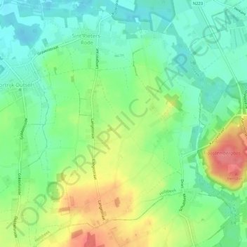
Name: Sint-Pieters-Rode topographic map, elevation, terrain.
Average elevation: 41 m
Minimum elevation: 13 m
Maximum elevation: 85 m
Thank you for supporting this site ❤️
Make a donation
Make a donation
Gear up for your next adventure:
As an Amazon Associate, this site earns from qualifying purchases at no extra cost to you.