Geolocate

Ritters topographic map

Click on the map to display elevation.

About this map

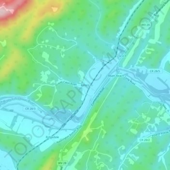
Name: Ritters topographic map, elevation, terrain.

Location: Ritters, Hampshire County, West Virginia, United States (39.40371 -78.74474 39.44371 -78.70474)

Average elevation: 243 m

Minimum elevation: 179 m

Maximum elevation: 489 m

Other topographic maps

Click on a map to view its topography, its elevation and its terrain.

Romney

United States > West Virginia > Hampshire County

Average elevation: 249 m

Romney

United States > West Virginia > Hampshire County

Average elevation: 249 m

Romney

United States > West Virginia > Hampshire County

Average elevation: 249 m

Gear up for your next adventure:

🥾All-Terrain Hiking Boots - Versatile boots for varied hiking conditions
🕶️Polarized Sunglasses - Protect your eyes with durable polarized lenses
🧢Outdoor Visor - Breathable visor for sunny hikes
🥾Lightweight Hiking Shoes - Comfortable shoes for day hikes
🥾Trail Running Boots - Durable shoes designed for trail running

As an Amazon Associate, this site earns from qualifying purchases at no extra cost to you.