
Make a donation
Gear up for your next adventure:
As an Amazon Associate, this site earns from qualifying purchases at no extra cost to you.
Brameloup topographic map
Click on the map to display elevation.
Make a donation
Gear up for your next adventure:
As an Amazon Associate, this site earns from qualifying purchases at no extra cost to you.
About this map
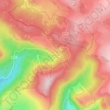
Name: Brameloup topographic map, elevation, terrain.
Average elevation: 1,261 m
Minimum elevation: 1,033 m
Maximum elevation: 1,382 m
Make a donation
Gear up for your next adventure:
As an Amazon Associate, this site earns from qualifying purchases at no extra cost to you.
Other topographic maps
Click on a map to view its topography, its elevation and its terrain.
La Boralde de Saint-Chély-d'Aubrac
France > Occitanie > Aveyron > Saint-Chély-d'Aubrac
Elle prend source à la frontière communale de Prades-d'Aubrac et Saint-Chély-d'Aubrac, à 1 309 m d'altitude. Elle coule globalement du nord-est vers le sud-ouest. Elle conflue en rive droite du Lot sur la commune de Saint-Côme-d'Olt à 355 m d'altitude
Average elevation: 854 m