
Make a donation
Gear up for your next adventure:
As an Amazon Associate, this site earns from qualifying purchases at no extra cost to you.
Heckenbeck topographic map
Click on the map to display elevation.
Make a donation
Gear up for your next adventure:
As an Amazon Associate, this site earns from qualifying purchases at no extra cost to you.
Heckenbeck
Der Stadtteil liegt etwa vier Kilometer nordwestlich von Bad Gandersheim abseits größerer Durchgangsstraßen im Tal am Bachlauf der Mahmilch, umrahmt von den bewaldeten Höhenzügen des Hellebergs (298 Meter), des Steinbrinks (227 Meter) und des Wadenbergs (249 Meter). Angebunden an die Kreisstraße 641 befindet sich Heckenbeck unweit der B64, welche Bad Gandersheim mit Kreiensen verbindet. Zwei Kilometer nördlich befindet sich das ebenfalls zu Heckenbeck gehörende Gut Hilprechtshausen.
Make a donation
Gear up for your next adventure:
As an Amazon Associate, this site earns from qualifying purchases at no extra cost to you.
About this map
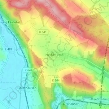
Name: Heckenbeck topographic map, elevation, terrain.
Average elevation: 173 m
Minimum elevation: 93 m
Maximum elevation: 282 m
Make a donation
Gear up for your next adventure:
As an Amazon Associate, this site earns from qualifying purchases at no extra cost to you.