
Make a donation
Gear up for your next adventure:
As an Amazon Associate, this site earns from qualifying purchases at no extra cost to you.
Gemaingoutte topographic map
Click on the map to display elevation.
Make a donation
Gear up for your next adventure:
As an Amazon Associate, this site earns from qualifying purchases at no extra cost to you.
Gemaingoutte
Son altitude varie entre 446 m et 995 m pour la partie la plus haute qui se trouve au lieu-dit du Violu. Important lieu de passage pendant les trois conflits mondiaux, de nombreux sentiers balisés permettent de se livrer à la promenade.
Make a donation
Gear up for your next adventure:
As an Amazon Associate, this site earns from qualifying purchases at no extra cost to you.
About this map
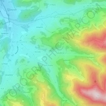
Name: Gemaingoutte topographic map, elevation, terrain.
Average elevation: 552 m
Minimum elevation: 393 m
Maximum elevation: 895 m
Make a donation
Gear up for your next adventure:
As an Amazon Associate, this site earns from qualifying purchases at no extra cost to you.