
Make a donation
Gear up for your next adventure:
As an Amazon Associate, this site earns from qualifying purchases at no extra cost to you.
Erp topographic map
Click on the map to display elevation.
Make a donation
Gear up for your next adventure:
As an Amazon Associate, this site earns from qualifying purchases at no extra cost to you.
Erp
Commune des Pyrénées située dans l'aire urbaine de Saint-Girons, à 8 km à l'est de Saint-Girons sur l'axe routier Saint-Girons - Massat. Elle fait partie de la communauté de communes Couserans - Pyrénées et du Parc naturel régional des Pyrénées ariégeoises. Elle s’étend sur une superficie de 948 ha dont 200 de forêt. L'altitude est comprise entre 400 mètres (centrale hydroélectrique de Lacourt) et 1 223 mètres, au cap d’Escouadès.
Make a donation
Gear up for your next adventure:
As an Amazon Associate, this site earns from qualifying purchases at no extra cost to you.
About this map
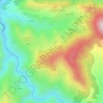
Name: Erp topographic map, elevation, terrain.
Average elevation: 719 m
Minimum elevation: 417 m
Maximum elevation: 1,177 m
Make a donation
Gear up for your next adventure:
As an Amazon Associate, this site earns from qualifying purchases at no extra cost to you.
Other topographic maps
Click on a map to view its topography, its elevation and its terrain.
Grotte Bernard
France > Occitanie > Ariège > Saint-Martin-de-Caralp > Le Fustié
Average elevation: 589 m
Make a donation
Gear up for your next adventure:
As an Amazon Associate, this site earns from qualifying purchases at no extra cost to you.