
Stranraer topographic map
Interactive map
Click on the map to display elevation.
About this map
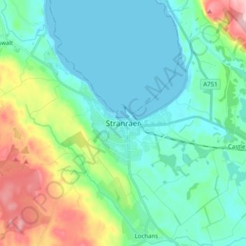
Name: Stranraer topographic map, elevation, terrain.
Location: Stranraer, Dumfries and Galloway, Écosse, DG9 7RT, Royaume-Uni (54.86443 -5.06620 54.94443 -4.98620)
Average elevation: 45 m
Minimum elevation: -1 m
Maximum elevation: 187 m
Other topographic maps
Click on a map to view its topography, its elevation and its terrain.
Waterbeck
Royaume-Uni > Écosse > Dumfries and Galloway
Waterbeck, Dumfries and Galloway, Écosse, DG11 3EY, Royaume-Uni
Average elevation: 128 m