Geolocate

Chalais topographic map

Click on the map to display elevation.

About this map
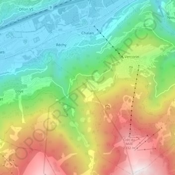
Name: Chalais topographic map, elevation, terrain.

Location: Chalais, Sierre, Valais central, Valais/Wallis, Switzerland (46.21618 7.47986 46.27685 7.56636)

Average elevation: 1,288 m

Minimum elevation: 502 m

Maximum elevation: 2,618 m

Other topographic maps

Click on a map to view its topography, its elevation and its terrain.
Pralong

Switzerland > Valais/Wallis > Sierre > Anniviers > Zinal

Average elevation: 2,141 m

Plans-Mayens

Switzerland > Valais/Wallis > Sierre

Average elevation: 1,501 m

Chandolin

Switzerland > Valais/Wallis > Sierre > Anniviers

Average elevation: 1,901 m

Gear up for your next adventure:

💧Filtered Water Bottle - Safe drinking water on the go
🥽Outdoor Goggles - Protective eyewear for outdoor activities
🛁Quick-Dry Microfiber Towel - Space-saving towel that dries rapidly on the move
🚲Heavy Duty Bike Lock - Secure your bike at the trailhead or during stops
🧤Rechargeable Heated Gloves - Extreme warmth for Canadian winter expeditions

As an Amazon Associate, this site earns from qualifying purchases at no extra cost to you.