Make a donation
Gear up for your next adventure:
As an Amazon Associate, this site earns from qualifying purchases at no extra cost to you.
Valencia topographic map
Click on the map to display elevation.
Make a donation
Gear up for your next adventure:
As an Amazon Associate, this site earns from qualifying purchases at no extra cost to you.
About this map
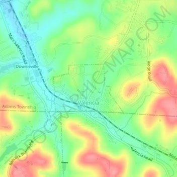
Name: Valencia topographic map, elevation, terrain.
Location: Valencia, Butler County, Pennsylvania, United States (40.67328 -79.99555 40.68073 -79.98141)
Average elevation: 351 m
Minimum elevation: 313 m
Maximum elevation: 402 m
Make a donation
Gear up for your next adventure:
As an Amazon Associate, this site earns from qualifying purchases at no extra cost to you.
Other topographic maps
Click on a map to view its topography, its elevation and its terrain.
Glade Mills
United States > Pennsylvania > Butler County > Middlesex Township
Average elevation: 359 m
Make a donation
Gear up for your next adventure:
As an Amazon Associate, this site earns from qualifying purchases at no extra cost to you.
Butler Farm Show Lake
United States > Pennsylvania > Butler County > Meridian
Average elevation: 392 m
Make a donation
Gear up for your next adventure:
As an Amazon Associate, this site earns from qualifying purchases at no extra cost to you.
Make a donation
Gear up for your next adventure:
As an Amazon Associate, this site earns from qualifying purchases at no extra cost to you.
