
Calar Alto topographic map
Click on the map to display elevation.
About this map
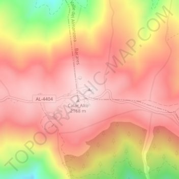
Name: Calar Alto topographic map, elevation, terrain.
Average elevation: 2,007 m
Minimum elevation: 1,675 m
Maximum elevation: 2,169 m
Other topographic maps
Click on a map to view its topography, its elevation and its terrain.
Sierra de Los Filabres
España > Andalucía > Valle del Almanzora > Bacares
La altitud media del complejo es de 1500 metros. Podemos destacar alturas superiores a los 2000 metros como Calar Alto, 2168 m s. n. m., Tetica de Bacares, 2080 m s. n. m. o Calar Gallinero, 2049 m s. n. m.
Average elevation: 1,398 m