
Make a donation
Gear up for your next adventure:
As an Amazon Associate, this site earns from qualifying purchases at no extra cost to you.
Marausa topographic map
Click on the map to display elevation.
Make a donation
Gear up for your next adventure:
As an Amazon Associate, this site earns from qualifying purchases at no extra cost to you.
About this map
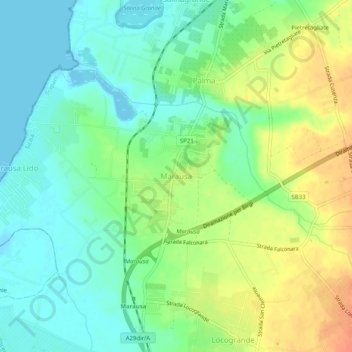
Name: Marausa topographic map, elevation, terrain.
Location: Marausa, Misiliscemi, Trapani, Sicilië, 91031, Italië (37.92043 12.49039 37.96043 12.53039)
Average elevation: 18 m
Minimum elevation: -1 m
Maximum elevation: 44 m
Make a donation
Gear up for your next adventure:
As an Amazon Associate, this site earns from qualifying purchases at no extra cost to you.
Other topographic maps
Click on a map to view its topography, its elevation and its terrain.
Erice
De stad ligt in het westen van Sicilië, de oude stad ligt hemelsbreed een paar kilometer van de stad Trapani, op een hoogte van 750 meter, op de top van de Monte San Giuliano en is via een kabelbaan verbonden met de voet van de berg, waar een deelgemeente of frazione van Erice, Casa Santa is gelegen. Vanwege…
Average elevation: 85 m