Geolocate

Horrheim topographic map

Click on the map to display elevation.

About this map

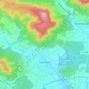
Name: Horrheim topographic map, elevation, terrain.

Location: Horrheim, Vaihingen an der Enz, VVG der Stadt Vaihingen an der Enz, Landkreis Ludwigsburg, Baden-Württemberg, Germany (48.96465 8.94061 49.01181 9.01038)

Average elevation: 277 m

Minimum elevation: 213 m

Maximum elevation: 475 m

Other topographic maps

Click on a map to view its topography, its elevation and its terrain.

Gear up for your next adventure:

🥘Camping Cookware Set - Compact nesting pots and pans for trail cooking
🎒Backpack Rain Cover - External shield to keep your entire pack dry
🥾Durable Hiking Shoes - Long-lasting shoes for frequent hiking
🏕️Camping Hammock - Integrated protection for sleeping between trees
🪜Heavy Duty Carabiners - Multi-use clips for securing gear to your backpack

As an Amazon Associate, this site earns from qualifying purchases at no extra cost to you.