
Pocol topographic map
Click on the map to display elevation.
About this map
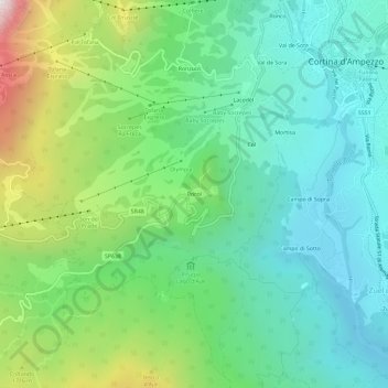
Name: Pocol topographic map, elevation, terrain.
Location: Pocol, Cortina d'Ampezzo, Belluno, Veneto, 32043, Italy (46.50463 12.09461 46.54463 12.13461)
Average elevation: 1,448 m
Minimum elevation: 1,106 m
Maximum elevation: 2,304 m
Other topographic maps
Click on a map to view its topography, its elevation and its terrain.
Gruppo del Pomagagnon
Italy > Veneto > Belluno > Cortina d'Ampezzo
Pomagagnon is a mountain of the Dolomites in Belluno, northern Italy. It has an elevation of 2,450 metres (8,038 ft) and is the southernmost mountain of the Cristallo Group, towering 1,200 metres (3,937 ft) over the resort of Cortina d'Ampezzo. The mountain is part of the "Natural Park of the Ampezzo…
Average elevation: 1,758 m