
Make a donation
Gear up for your next adventure:
As an Amazon Associate, this site earns from qualifying purchases at no extra cost to you.
Framsden topographic map
Click on the map to display elevation.
Make a donation
Gear up for your next adventure:
As an Amazon Associate, this site earns from qualifying purchases at no extra cost to you.
About this map
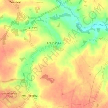
Name: Framsden topographic map, elevation, terrain.
Location: Framsden, Mid Suffolk, Suffolk, England, United Kingdom (52.16897 1.19027 52.20930 1.25721)
Average elevation: 49 m
Minimum elevation: 20 m
Maximum elevation: 66 m
Make a donation
Gear up for your next adventure:
As an Amazon Associate, this site earns from qualifying purchases at no extra cost to you.
Other topographic maps
Click on a map to view its topography, its elevation and its terrain.
Make a donation
Gear up for your next adventure:
As an Amazon Associate, this site earns from qualifying purchases at no extra cost to you.
Make a donation
Gear up for your next adventure:
As an Amazon Associate, this site earns from qualifying purchases at no extra cost to you.
Make a donation
Gear up for your next adventure:
As an Amazon Associate, this site earns from qualifying purchases at no extra cost to you.
Thorpe Street
United Kingdom > England > Suffolk > Mid Suffolk > Hinderclay > Thorpe Street
Average elevation: 36 m
Make a donation
Gear up for your next adventure:
As an Amazon Associate, this site earns from qualifying purchases at no extra cost to you.
Withersdale Street
United Kingdom > England > Suffolk > Mid Suffolk > Mendham > Withersdale Street
Average elevation: 38 m
Make a donation
Gear up for your next adventure:
As an Amazon Associate, this site earns from qualifying purchases at no extra cost to you.