
Make a donation
Gear up for your next adventure:
As an Amazon Associate, this site earns from qualifying purchases at no extra cost to you.
Koldingen topographic map
Click on the map to display elevation.
Make a donation
Gear up for your next adventure:
As an Amazon Associate, this site earns from qualifying purchases at no extra cost to you.
Koldingen
Im 13. oder 14. Jahrhundert entstand die Burg Koldingen als Wasserburg zur Sicherung des Leineübergangs. In den Jahren von 1372 bis 1380 wurde die Burg von den Bischöfen von Hildesheim zu einem Amtsschloss umgebaut. Das Bistum Hildesheim errichtete in der Mitte des 15. Jahrhunderts südlich der schon bestehenden Burg die „Oberste Borch“ auf einer Anhöhe. Beide Burgen wurden in der Hildesheimer Stiftsfehde zwischen 1519 und 1523 zerstört. Als Folge wurde Koldingen welfisch und Sitz des Amtes Koldingen. 1593 ließ Herzog Heinrich Julius das existierende Amtshaus Koldingen errichten. Das Amt bestand bis 1824.
Make a donation
Gear up for your next adventure:
As an Amazon Associate, this site earns from qualifying purchases at no extra cost to you.
About this map
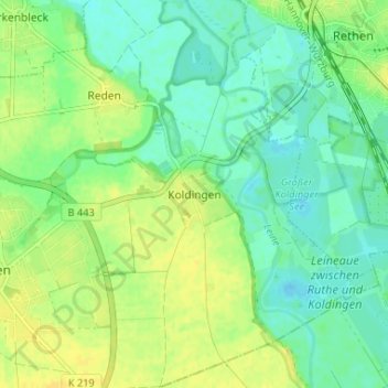
Name: Koldingen topographic map, elevation, terrain.
Average elevation: 64 m
Minimum elevation: 54 m
Maximum elevation: 76 m
Make a donation
Gear up for your next adventure:
As an Amazon Associate, this site earns from qualifying purchases at no extra cost to you.