Geolocate

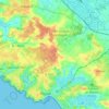
La Robinière topographic map

Click on the map to display elevation.

About this map

Name: La Robinière topographic map, elevation, terrain.

Location: La Robinière, Royan, Rochefort, Charente-Maritime, Nouvelle-Aquitaine, France métropolitaine, 17200, France (45.60940 -1.02044 45.64940 -0.98044)

Average elevation: 10 m

Minimum elevation: -2 m

Maximum elevation: 32 m

Other topographic maps

Click on a map to view its topography, its elevation and its terrain.

17200

France > Nouvelle-Aquitaine > Charente-Maritime > Royan

Average elevation: 14 m

Gear up for your next adventure:

🧥Waterproof Pants - Keep dry during rainy hiking conditions
💡LED Camping Lantern - Illuminate your campsite with long-lasting lanterns
🧥Softshell Jacket - Windproof and breathable jacket for hiking
🪑Ultralight Camping Stool - Compact seating for rest stops during long hikes
🛶Kayak Dry Bag - Waterproof storage for kayaking adventures

As an Amazon Associate, this site earns from qualifying purchases at no extra cost to you.