
Make a donation
Gear up for your next adventure:
As an Amazon Associate, this site earns from qualifying purchases at no extra cost to you.
My topographic map
Click on the map to display elevation.
Make a donation
Gear up for your next adventure:
As an Amazon Associate, this site earns from qualifying purchases at no extra cost to you.
About this map
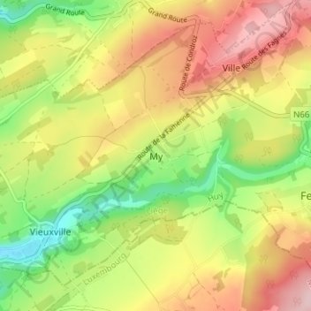
Name: My topographic map, elevation, terrain.
Location: My, Ferrières, Huy, Liège, Wallonia, 4190, Belgium (50.38526 5.55260 50.42526 5.59260)
Average elevation: 244 m
Minimum elevation: 137 m
Maximum elevation: 352 m
Make a donation
Gear up for your next adventure:
As an Amazon Associate, this site earns from qualifying purchases at no extra cost to you.
Other topographic maps
Click on a map to view its topography, its elevation and its terrain.
Bassin de décantation des résidus miniers
Belgium > Liège > Huy > Wanze > Huccorgne > Le Taillis
Average elevation: 133 m
Make a donation
Gear up for your next adventure:
As an Amazon Associate, this site earns from qualifying purchases at no extra cost to you.