
Make a donation
Gear up for your next adventure:
As an Amazon Associate, this site earns from qualifying purchases at no extra cost to you.
Saint-Hugues-de-Chartreuse topographic map
Click on the map to display elevation.
Make a donation
Gear up for your next adventure:
As an Amazon Associate, this site earns from qualifying purchases at no extra cost to you.
Saint-Hugues-de-Chartreuse
Saint-Hugues-de-Chartreuse est un petit village situé dans la commune de Saint-Pierre-de-Chartreuse, en Isère, dans le massif de la Chartreuse. Il est situé à 3 km du chef-lieu et à 30 km de Grenoble. Il culmine à environ 900 m d'altitude.
Make a donation
Gear up for your next adventure:
As an Amazon Associate, this site earns from qualifying purchases at no extra cost to you.
About this map
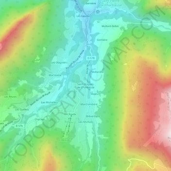
Name: Saint-Hugues-de-Chartreuse topographic map, elevation, terrain.
Average elevation: 1,117 m
Minimum elevation: 794 m
Maximum elevation: 1,722 m
Make a donation
Gear up for your next adventure:
As an Amazon Associate, this site earns from qualifying purchases at no extra cost to you.
Other topographic maps
Click on a map to view its topography, its elevation and its terrain.
Le Guiers Mort
France > Auvergne-Rhône-Alpes > Isère > Saint-Pierre-de-Chartreuse
Average elevation: 964 m