
Make a donation
Gear up for your next adventure:
As an Amazon Associate, this site earns from qualifying purchases at no extra cost to you.
La Saline topographic map
Click on the map to display elevation.
Make a donation
Gear up for your next adventure:
As an Amazon Associate, this site earns from qualifying purchases at no extra cost to you.
La Saline
Le village se situe à 500 m d'altitude à 10 minutes de la Route des Tamarins.
Make a donation
Gear up for your next adventure:
As an Amazon Associate, this site earns from qualifying purchases at no extra cost to you.
About this map
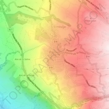
Name: La Saline topographic map, elevation, terrain.
Location: La Saline, Saint-Paul, La Réunion, 97422, France (-21.10370 55.24863 -21.06370 55.28863)
Average elevation: 417 m
Minimum elevation: 11 m
Maximum elevation: 701 m
Make a donation
Gear up for your next adventure:
As an Amazon Associate, this site earns from qualifying purchases at no extra cost to you.
Other topographic maps
Click on a map to view its topography, its elevation and its terrain.
Ravine Saint-Gilles
France > La Réunion > Saint-Paul > Saint-Gilles-les-Hauts > Village de l'Éperon
Average elevation: 310 m
Make a donation
Gear up for your next adventure:
As an Amazon Associate, this site earns from qualifying purchases at no extra cost to you.