Geolocate

Ede topographic map

Click on the map to display elevation.

About this map

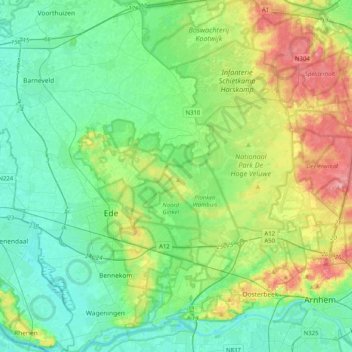
Name: Ede topographic map, elevation, terrain.

Location: Ede, Gelderland, Netherlands (51.99095 5.54674 52.15223 5.95147)

Average elevation: 30 m

Minimum elevation: 2 m

Maximum elevation: 101 m

Other topographic maps

Click on a map to view its topography, its elevation and its terrain.

Oud-Zevenaar

Netherlands > Gelderland > Zevenaar

Average elevation: 12 m

Gear up for your next adventure:

🧢Outdoor Cap - Protective cap for sun and rain during hikes
🪜Heavy Duty Carabiners - Multi-use clips for securing gear to your backpack
🧦Hiking Socks - Moisture-wicking and comfortable socks for long hikes
🥾Approach Boots - Comfortable boots for hiking and climbing approaches
Backpacking Tent - Lightweight tent for long-distance hiking trips

As an Amazon Associate, this site earns from qualifying purchases at no extra cost to you.