
Make a donation
Gear up for your next adventure:
As an Amazon Associate, this site earns from qualifying purchases at no extra cost to you.
Chodavaram topographic map
Click on the map to display elevation.
Make a donation
Gear up for your next adventure:
As an Amazon Associate, this site earns from qualifying purchases at no extra cost to you.
About this map
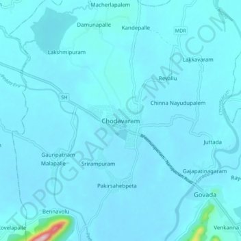
Name: Chodavaram topographic map, elevation, terrain.
Location: Chodavaram, Anakapalli, Andhra Pradesh, 531036, India (17.78968 82.89448 17.86968 82.97448)
Average elevation: 50 m
Minimum elevation: 35 m
Maximum elevation: 364 m
Make a donation
Gear up for your next adventure:
As an Amazon Associate, this site earns from qualifying purchases at no extra cost to you.
Other topographic maps
Click on a map to view its topography, its elevation and its terrain.
Sarada
India > Andhra Pradesh > Chodavaram
The catchment area of the basin is 2,665 square kilometers. It rises at an elevation of 1,000 meters in the Eastern Ghats. It runs eastwards for a distance 122 kilometers and joins the Bay of Bengal.
Average elevation: 222 m