
Make a donation
Gear up for your next adventure:
As an Amazon Associate, this site earns from qualifying purchases at no extra cost to you.
Bald Hill topographic map
Click on the map to display elevation.
Make a donation
Gear up for your next adventure:
As an Amazon Associate, this site earns from qualifying purchases at no extra cost to you.
About this map
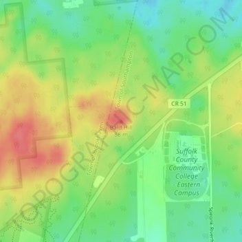
Name: Bald Hill topographic map, elevation, terrain.
Average elevation: 47 m
Minimum elevation: 18 m
Maximum elevation: 80 m
Make a donation
Gear up for your next adventure:
As an Amazon Associate, this site earns from qualifying purchases at no extra cost to you.
Other topographic maps
Click on a map to view its topography, its elevation and its terrain.
Shinnecock Hills
United States > New York > Suffolk County > Town of Southampton
Average elevation: 5 m
Quiogue
United States > New York > Suffolk County > Town of Southampton
Quiogue is located at 40°49′11″N 072°37′44″W / 40.81972°N 72.62889°W / 40.81972; -72.62889 (40.8198217, -72.6289837) and its elevation is 23 feet (7 m).
Average elevation: 5 m
Make a donation
Gear up for your next adventure:
As an Amazon Associate, this site earns from qualifying purchases at no extra cost to you.