
Make a donation
Gear up for your next adventure:
As an Amazon Associate, this site earns from qualifying purchases at no extra cost to you.
Fort Bragg topographic map
Click on the map to display elevation.
Make a donation
Gear up for your next adventure:
As an Amazon Associate, this site earns from qualifying purchases at no extra cost to you.
Fort Bragg
Fort Bragg, officially the City of Fort Bragg, is a city along the Pacific Coast of California along Shoreline Highway in Mendocino County. The city is 24 miles (39 km) west of Willits, at an elevation of 85 feet (26 m). Its population was 6,983 at the 2020 census.
Make a donation
Gear up for your next adventure:
As an Amazon Associate, this site earns from qualifying purchases at no extra cost to you.
About this map
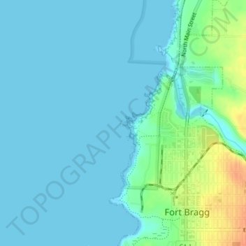
Name: Fort Bragg topographic map, elevation, terrain.
Location: Fort Bragg, Mendocino County, California, United States (39.45312 -123.81527 39.45373 -123.81428)
Average elevation: 8 m
Minimum elevation: -2 m
Maximum elevation: 39 m
Make a donation
Gear up for your next adventure:
As an Amazon Associate, this site earns from qualifying purchases at no extra cost to you.
Other topographic maps
Click on a map to view its topography, its elevation and its terrain.
Laytonville
United States > California > Mendocino County
Laytonville is a census-designated place (CDP) in Mendocino County, California, United States. It is located 23 miles (37 km) north-northwest of Willits, at an elevation of 1,670 feet (510 m). The population was 1,152 at the 2020 census, down from 1,227 at the 2010 census.
Average elevation: 594 m
Talmage
United States > California > Mendocino County
Talmage (variant, Talmadge) is a census-designated place (CDP) in Mendocino County, California, United States. Talmage is located 2.5 miles (4 km) east-southeast of Ukiah, at an elevation of 627 feet (191 m). The population was 986 at the 2020 census, down from 1,130 in 2010. It lies in the southeastern part…
Average elevation: 200 m
Make a donation
Gear up for your next adventure:
As an Amazon Associate, this site earns from qualifying purchases at no extra cost to you.
Brooktrails
United States > California > Mendocino County
Brooktrails is in central Mendocino County, occupying hills to the west of Little Lake Valley. The fire department and golf course lie at an elevation of 1,634 feet (498 m), but the community's western edge rises to nearly 3,000 feet (910 m). It is 3 miles (5 km) north of Willits. According to the United…
Average elevation: 569 m
Make a donation
Gear up for your next adventure:
As an Amazon Associate, this site earns from qualifying purchases at no extra cost to you.